How Digital Twin Visualisation Will Shape Projects in 2026 

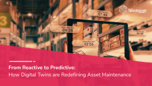
Digital twins have moved past the hype phase. By 2026, the conversation is no longer about whether organisations should adopt them, but how effectively they can use them. What is changing most is not the availability of data or modelling tools, but how that information is visualised and used by people making decisions. 

Digital twin visualisation is moving from a specialist function to a shared, everyday project tool. It allows teams to see systems as they really behave, understand problems in context, and test decisions before they are made in the real world. As projects face increasing complexity, tighter budgets, and greater risk exposure, this shift is reshaping how work gets done. 

Why Visualisation Is the Missing Link in Digital Twins 

At its core, a digital twin is a combination of data, models, and logic that represents a physical asset or system. On its own, that information can be overwhelming. Sensors generate continuous streams of data. Simulation models produce complex outputs. Schedules, cost plans, and maintenance records sit in separate systems. 

Visualisation connects all of this into a single, understandable view. 

By 2026, effective digital twin visualisation is what separates useful twins from underused ones. Instead of forcing people to interpret spreadsheets or dashboards in isolation, visual twins show what is happening, where it is happening, and how different factors influence each other. 

This matters because most project decisions are made under time pressure. Clear visual context allows teams to understand issues quickly and respond with confidence. 

Moving Beyond Design and Into Daily Operations 

Digital twins first gained traction in design and engineering. They were used to validate geometry, check clashes, and test layouts. While those uses remain important, visualisation in 2026 extends far beyond the design phase. 

Projects increasingly rely on digital twins throughout construction, commissioning, and operations. Visualisation supports this by showing how assets evolve over time, not just how they look on day one. 

For example: 

  • Construction teams can compare planned versus actual progress in a visual timeline. 
  • Operators can see performance trends mapped directly onto equipment or facilities. 
  • Asset owners can understand how early design decisions affect long-term maintenance and operating costs. 

This continuous visual feedback helps prevent the common disconnect between design intent and operational reality. 

Real-Time Awareness Changes Project Control 

One of the most significant developments shaping projects in 2026 is real-time digital twin visualisation. 

Sensors, automation systems, drones, and site scanning technologies constantly update the digital twin. Visual interfaces turn these live data feeds into dynamic representations of current conditions. 

This transforms project control in practical ways: 

  • Issues are identified earlier, often before they escalate into delays or failures. 
  • Site conditions, safety risks, and quality concerns are visible as they emerge. 
  • Decisions are based on current reality rather than outdated reports. 

Instead of managing by exception after problems occur, teams manage by insight as conditions change. 

Visualisation Enables Better Problem Solving 

Projects rarely fail because of a lack of data. They fail because problems are misunderstood, ignored, or identified too late. 

Digital twin visualisation addresses this by making problems visible and contextual. 

By 2026, teams routinely use visual twins to: 

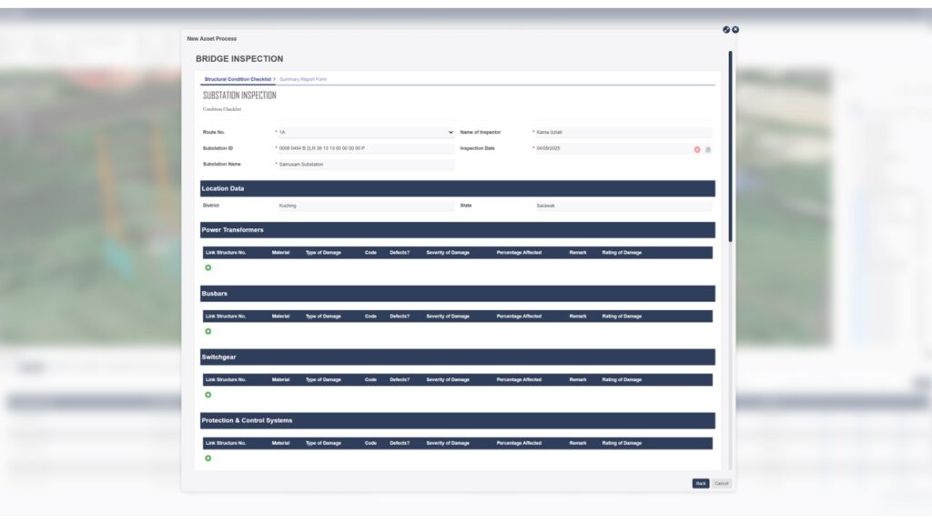
  • Trace the root cause of recurring equipment issues 
  • Identify process bottlenecks in manufacturing or logistics 
  • Understand how changes in one area affect the wider system 
  • Evaluate safety risks under different operating conditions 

When problems are visualised within the context of the full system, solutions become clearer. Discussions shift from opinions to evidence, reducing friction between disciplines. 

Scenario Simulation Becomes Standard Practice 

Another way that digital twin visualisation shapes projects in 2026 is through scenario simulation. 

Rather than relying on static forecasts or assumptions, teams use visual twins to explore “what if” scenarios before committing resources. These simulations allow decision-makers to see potential outcomes unfold over time. 

Common use cases include: 

  • Assessing the impact of schedule changes on cost and delivery 
  • Testing how assets perform under extreme weather or demand spikes 
  • Evaluating design alternatives based on long-term operational performance 
  • Planning maintenance strategies that minimise downtime 

Because these scenarios are visual and time-based, they are easier to understand and communicate. This is especially valuable when decisions involve multiple stakeholders with different levels of technical expertise. 

Supporting the Entire Asset Lifecycle 

One of the most powerful aspects of digital twin visualisation in 2026 is lifecycle continuity. 

Traditionally, information is lost as projects move from design to construction to operations. Digital twins help preserve that knowledge, and visualisation makes it accessible long after handover. 

The same visual twin can support: 

  • Designers refining intent 
  • Contractors coordinating delivery 
  • Operators optimising performance 
  • Owners planning upgrades or expansions 

This continuity reduces rework, improves asset performance, and ensures decisions are informed by a complete understanding of the system’s history. 

Visual Collaboration Across Distributed Teams 

Projects are increasingly global and multidisciplinary. Teams work across locations, organisations, and time zones. Visualisation plays a critical role in keeping everyone aligned. 

By 2026, collaboration often happens directly within the digital twin. Teams review issues, propose changes, and approve decisions in a shared visual environment rather than through disconnected documents. 

This approach: 

  • Reduces misunderstandings caused by interpreting drawings differently 
  • Speeds up reviews and approvals 
  • Makes complex systems easier to explain to non-technical stakeholders 

Visual collaboration turns the digital twin into a common language for the project. 

AI and Predictive Insight Made Visible 

Artificial intelligence and advanced analytics are becoming deeply integrated with digital twins. However, their value depends on how well insights are communicated. 

Visualisation is what makes predictive intelligence actionable. 

In 2026, digital twins do not just show what is happening now. They highlight what is likely to happen next. Risk areas, performance trends, and future scenarios are presented visually within the context of real assets and processes. 

Examples include: 

  • Predicting equipment failure and highlighting affected systems 
  • Forecasting demand and visualising capacity constraints 
  • Identifying cost and schedule risks before they materialise 

This builds trust in predictive models and helps teams act earlier and more effectively. 

Industries Seeing the Greatest Impact 

While digital twin visualisation is spreading across many sectors, its impact is especially clear in: 

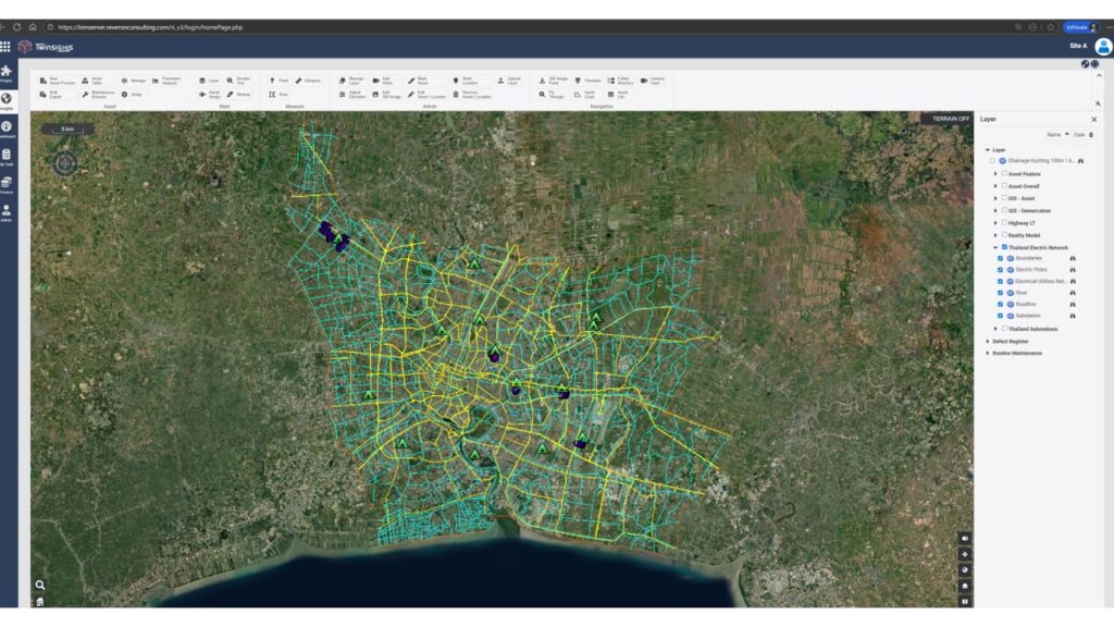
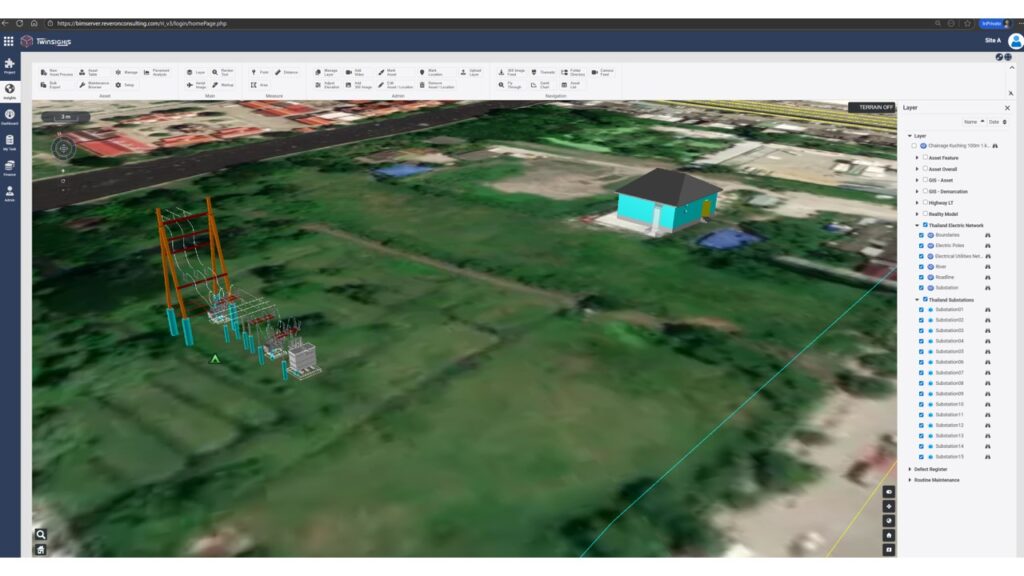
  • Construction and infrastructure, where coordination, safety, and risk management are critical 
  • Industrial and manufacturing projects, where uptime and efficiency drive value 
  • Energy and utilities, where resilience and performance optimisation are essential 
  • Smart cities, where visual twins support planning, operations, and public engagement 

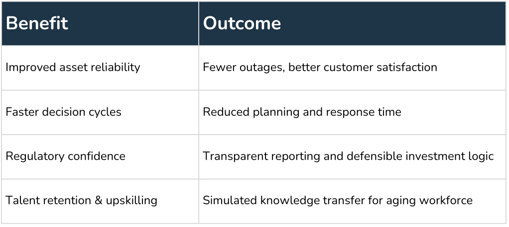
Across all these areas, the common theme is improved decision-making through clearer understanding. 

Looking Ahead to 2026 

Digital twin visualisation is not about impressive graphics or complex interfaces. Its real value lies in clarity. 

By 2026, successful projects are those where teams can clearly see what is happening, understand how systems interact, and anticipate the consequences of their decisions. Visual digital twins make that possible. 

They turn data into insight, insight into action, and action into better outcomes. As complexity and uncertainty continue to grow, digital twin visualisation will not just support projects. It will shape how they succeed. 

For more updates, follow us on LinkedInTwitterFacebook, and Instagram.

From Maps to Management: Leveraging Geospatial Capabilities for Road Assets 

Road networks have evolved into high-density asset corridors that require precise spatial intelligence to manage effectively. Conventional mapping, periodic inspections and document-based workflows cannot support the level of granularity or update frequency needed for modern operations. What closes that gap is the integration of geospatial data, reality capture and digital-twin frameworks into a single operational environment. 

A road network is no longer a line on a map. It is a time-variant system containing pavement structures, subsurface utilities, drainage assets, slopes, structures and traffic control devices, all interacting with terrain, climate and load. Geospatial capability allows these layers to be indexed, modelled and analysed as a connected system rather than isolated datasets. This shift marks the movement from map-based oversight to full asset lifecycle management. 

Why geospatial capability matters now 

Road assets are profoundly spatial. A pavement crack is not just a defect. It is a point on a network, affected by weather, drainage, stress levels and adjoining features. Managing roads without spatial context is like trying to run a city with the lights turned off. 

Geospatial technology fixes this problem by giving every asset a location, context and time history. Today’s systems can layer drone imagery, mobile mapping, LiDAR scans and sensor data on top of traditional GIS inputs. The result is a complete picture of the network, down to the millimeter if needed. 

This shift matters for three reasons: 

1. Condition and location finally speak to each other. 

You do not just see a broken signpost. You see its relation to a sharp curve, heavy freight movement or a recurring flooding zone. 

2. Updates come fast. 

Instead of waiting months for inspection rounds, road operators can use drone runs, drive-through cameras or IoT sensors to refresh the picture. 

3. Data becomes action. 

With the right platform, spatial data can drive planning, scheduling, budgeting and long-term strategy, not just static reporting. 

Geospatial foundations for road-asset intelligence 

Modern road-asset management relies on five core geospatial components: 

a) Spatially referenced asset inventories 

Every asset must have a unique spatial identifier. GIS schemas now support multi-attribute models that link geometry, material properties, condition ratings, inspection records and maintenance history. This geospatial backbone enables operators to perform network-level queries such as deterioration clustering, performance comparison across terrain types and spatial risk mapping. 

b) High-resolution reality capture 

Drone photogrammetry, mobile LiDAR, static scanning and satellite data feed continuous geometry and surface condition updates. Automated point-cloud processing and mesh reconstruction allow for sub-centimeter accuracy in representing pavement surfaces, structures and surrounding topography. 

c) Temporal data integration 

Road conditions shift rapidly due to traffic loading, water infiltration and temperature cycles. Geospatial systems designed for asset management incorporate versioning, so operators can track condition deltas over time and generate deterioration curves that feed predictive models. 

d) Sensor and IoT integration 

Strain gauges, embedded pavement sensors, weather stations and connected-vehicle telemetry provide real-time performance signals. When geospatially anchored, these data streams identify anomalies in context (for example, elevated vibration readings on segments already flagged for rutting). 

e) Spatial analytics and modelling 

Geospatial analytics allow queries such as hydro-flow mapping, slope stability assessment, drainage catchment analysis and traffic-load distribution modelling. The output strengthens engineering decisions around intervention prioritisation, widening options and corridor optimisation. 

What geospatial-driven asset management with Twinsights looks like 

When geospatial capability supports road-asset management, four things become possible right away. 

a) A unified, network-wide asset inventory 

Every culvert, barrier, pavement segment, lamp post, retaining wall and embankment can be geo-tagged and stored in one system. This is more than housekeeping. It allows you to see clusters of risk, patterns of deterioration and links between terrain and performance. 

b) Real time condition understanding 

Drone surveys, vehicle-mounted cameras and mobile LiDAR can scan long stretches of road quickly. These feeds can update the digital twin and flag early failure signs: rutting, cracking, settlement, erosion or vegetation encroachment. 

c) Lifecycle tracking 

Road assets are not just built and forgotten. They age, shift, weaken and sometimes fail. A geospatially aware twin tracks this movement. It becomes a memory bank that shows what changed, when and why. 

d) Predictive maintenance 

With consistent data flowing into a central model, analytics can forecast risk. Pavement deterioration curves, drainage performance under heavy storms, slope instability, guardrail strength over time. Predictive maintenance lets teams stay ahead rather than chase breakdowns. 

Digital twins as the operational layer 

A digital twin for a road network consolidates design models, construction progress, as-built records, sensor inputs and condition data into a single operational model. Unlike static BIM or GIS files, the twin is continuously updated and reflects the network’s real-world state. 

Key technical capabilities include: 

Lifecycle integration 

  • Design data: alignments, pavement structures, utility layouts, clear zones, drainage geometry. 
  • Construction data: actual progress, deviations from design, material sampling and QC results. 
  • Operations data: condition scores, safety audits, work orders, maintenance closures. 

Spatial-temporal visualisation 

The twin allows operators to navigate the network by chainage, by asset class or by condition state. Changes over time are tracked through delta analysis applied to point clouds, meshes and condition layers. 

Simulation and scenario modelling 

Digital twins support simulations such as: 

  • Pavement performance under variable traffic loading. 
  • Drainage response under design storms. 
  • Slope stability sensitivity to rainfall intensity. 
  • Maintenance prioritisation based on risk scoring. 

This moves decision-making from experience-based judgement to evidence-based optimisation. 

Engineering workflows enabled by Twinsights’ asset management 

a) Network-wide condition assessment 

Reality-capture data can be processed through automated defect-detection algorithms to identify rutting, cracking, potholes, fretting, joint distress and edge drop-off. These defects can then be classified by severity and mapped against terrain, drainage and traffic conditions. 

b) Failure prediction and risk modelling 

Machine-learning models trained on historical condition changes, spatial attributes and climate inputs can forecast failure probability for each segment. 

Inputs typically include: 

  • Pavement layer thickness and material properties 
  • Subgrade conditions 
  • Traffic axle loading 
  • Drainage performance indicators 
  • Temperature and moisture cycles 

Outputs guide budgets, resurfacing schedules and corridor-level risk registers. 

c) Corridor optimisation and design review 

Geospatial data combined with design models enables engineers to: 

  • Detect alignment clashes or right-of-way constraints 
  • Evaluate cut-and-fill balances more accurately 
  • Optimise drainage design using terrain flow paths 
  • Assess environmental impact through spatial overlays 

This improves design accuracy and reduces redesign cycles. 

d) Construction monitoring 

Drone and LiDAR data compared against design surfaces produce heatmaps of deviations. This ensures compliance with tolerances for pavement layers, compaction, embankment geometry and structure positioning. Document control and spatial markup tools reduce site revisits and RFIs. 

e) Maintenance planning and execution 

With a digital twin, maintenance planners can schedule interventions based on the spatial clustering of defects, optimal crew routing, traffic management needs and predicted deterioration rates. Work orders can be geo-tagged and reflected instantly in the model. 

Technical outcomes and performance gains 

Agencies adopting geospatial-enabled digital twins typically achieve: 

  • 30 to 50% reductions in field inspection hours due to automated capture. 
  • Improved pavement asset accuracy through high-resolution terrain and surface data. 
  • Lower lifecycle costs driven by predictive maintenance schedules. 
  • Higher construction compliance rates using delta-surface comparisons. 
  • Real-time situational awareness during closures, incidents or extreme weather. 
  • More accurate budgeting due to risk-based asset deterioration models. 

The net effect is a shift from corrective maintenance to predictive asset stewardship. 

Conclusion 

Road-asset management is now a spatial computing problem. High-resolution capture, GIS intelligence and digital-twin operations give engineers a multi-layered, time-aware understanding of their networks. These tools connect geometry, condition, performance and prediction into a single management engine. 

For asset owners and operators, the path forward is clear: build a strong geospatial foundation, tie it to a live digital twin and use analytics to drive decisions. The result is a resilient, cost-efficient and technically defensible way to manage road networks at scale. 

For more updates, follow us on LinkedInTwitterFacebook, and Instagram.

Twinsights: Bridging Departmental Silos Through ERP Integration for Asset Operators 

Asset operator organizations are inherently complex. They manage sprawling portfolios of infrastructure, equipment, and facilities, each supported by specialized teams—finance, contracts, operations, maintenance, engineering, and compliance. To keep these functions running, organizations rely on ERP systems as their enterprise backbone, alongside engineering platforms (BIM, GIS), IoT telemetry, and project management tools. 

Asset operators rely on ERP systems as their enterprise backbone, alongside engineering platforms (BIM, GIS), IoT telemetry, and project management tools

Figure:  Asset operators rely on ERP systems as their enterprise backbone, alongside engineering platforms (BIM, GIS), IoT telemetry, and project management tools. 

Each system is powerful, but each is also designed with a departmental lens. Finance optimizes for cost control, operations for uptime, contracts for compliance. The result is a departmentalized environment where processes are optimized locally but fragmented globally. Whenever a business process spans multiple functions—such as acquiring services or managing long‑term agreements—integration becomes essential. 

Without integration, each team works in isolation, duplicating effort and missing opportunities for efficiency. With integration, workflows become seamless, decisions are faster, and the organization operates as one. 

That’s where Twinsights, Digile’s digital twin platform, comes in. 

Why ERP Matters: The Industry Backbone 

ERP platforms are the system of record for most asset operators. They manage contracts, procurement, costs, and compliance, ensuring standardized processes and governance across the enterprise. 

The strength of ERP lies in its centralization and standardization. Once core processes are embedded, organizations gain stability, compliance, and scalability. But ERP systems are not designed to provide immersive visualization, predictive insights, or cross‑departmental orchestration on their own. 

That’s where Twinsights comes in—extending ERP’s transactional power with contextual intelligence. 

Twinsights: The Unified Layer for Asset Operators 

Twinsights delivers powerful enterprise integration capabilities that seamlessly connect data, workflows, and stakeholder collaboration across infrastructure, asset management, and smart city ecosystems. Its platform enables unified operations by bridging technical silos and aligning cross-functional teams throughout the entire lifecycle. 

Enterprise System Integration with Twinsights

Figure:  Enterprise System Integration with Twinsights. 

Twinsights addresses the integration challenge by acting as the digital twin intelligence layer that sits on top of ERP and other enterprise systems. It doesn’t replace ERP—it enhances it, bridging the gap between transactional data and operational intelligence. 

🔗 Unified Data Integration 

  • Connects ERP modules (contracts, costs, maintenance) with engineering, GIS, and IoT data. 
  • Ensures contract managers and cost controllers see the same information in real time. 

🛠️ Cross-Departmental Workflows 

  • Automates processes that span multiple teams, such as contract approvals that trigger cost updates in ERP. 
  • Eliminates manual handovers and ensures consistency across departments. 

🌍 Contextual Visualization & Executive Dashboards 

  • Teams can see how contractual changes affect physical assets, budgets, and schedules in one view. 
  • Leaders gain a holistic view of performance, costs, and risks without waiting for siloed reports. 

Example: Contract and Cost Teams Working Together 

Asset operators deal with large, distributed assets (e.g., power plants, substations, pipelines, treatment plants, meters, etc.). Keeping these assets operational requires a constant flow of spare parts, consumables, and contracted services.  

Material management process in ERP for asset operators. 

Figure:  Material management process in ERP for asset operators. 

As illustrated in the diagram above: 

  • Requisition → A maintenance engineer raises a purchase requisition for a spare part or service. 
  • Purchase Order → Procurement converts it into a purchase order with an approved vendor. 
  • Goods Receipt → Materials arrive at the warehouse, and stock is updated in ERP. 
  • Goods Issue → The part is issued to a technician for field work, linked to a work order. 
  • Invoice Verification → Vendor invoice is matched against PO and GR. 
  • Payment → Finance processes payment, with costs allocated to the right cost center 
Twinsights and ERP (e.g., SAP) integration for material management process. 

Figure:  Twinsights and ERP (e.g., SAP) integration for material management process. 

Consider a scenario where an asset operator needs to procure engineering services as part of its routine maintenance operations. Engaging the contractor requires navigating the organization’s established standard operating procedures (SOPs), which often mandate additional approval workflows beyond what the ERP system alone supports. These layered approvals ensure compliance with internal governance and control frameworks before the service request can advance. While Twinsights is designed to integrate with a range of ERP platforms, its deployment alongside SAP serves as the illustrative example in this context, demonstrating how localized approvals in Twinsights can seamlessly trigger downstream procurement actions in the ERP environment. 

Localizing approvals in Twinsights can seamlessly trigger downstream procurement actions in the ERP environment. 

Figure: Localizing approvals in Twinsights can seamlessly trigger downstream procurement actions in the ERP environment. 

The integration between Twinsights and ERP systems can operate in a bi‑directional manner, ensuring data consistency across platforms. Within the service acquisition process, establishing an Outline Agreement (OA) is a critical step. An OA represents a long‑term purchasing framework between an organization and a vendor, defining agreed terms and conditions for the supply of materials or services over a specified validity period. In practice, it functions as an “umbrella contract” under which multiple purchase orders or scheduled deliveries can be executed. When the OA is created and managed in the ERP system, its approval status and key details can be seamlessly synchronized back into Twinsights through the integration framework, giving stakeholders unified visibility and control 

Material management process in ERP for asset operators. 

Figure:  Material management process in ERP for asset operators. 

With Twinsights, asset operators move beyond simple system connectivity to true organizational alignment. The platform establishes a single source of truth, ensuring that data flows seamlessly across functions. As a result, contract management and cost management teams can collaborate within a unified environment, working from the same information and driving decisions with greater speed, accuracy, and confidence. 

How Digile Enables Success 

As the creator of Twinsights, Digile provides both the platform and the expertise to ensure successful ERP integration: 

  1. ERP Implementation & Rollout – End‑to‑end ERP projects, module configuration, and integration with Twinsights. 
  1. Integration Architecture – Scalable, API‑driven designs leveraging middleware for secure, governed data exchange. 
  1. Process Mapping – Cross‑departmental workflows (service acquisition, agreement management, maintenance‑to‑finance). 
  1. Executive Storytelling – Translating technical integration into ROI and risk‑mitigation narratives. 
  1. User Adoption & Training – Role‑based enablement to ensure teams embrace new workflows. 
  1. Continuous Improvement – Governance frameworks, KPIs, and ESG reporting maturity. 

Conclusion: From Departmental Silos to Unified Operations 

For asset operator organizations, departmentalization is both a strength and a challenge. Specialized teams ensure expertise, but when processes span across functions, integration becomes essential. 

ERP remains the backbone of enterprise operations, trusted by the world’s largest companies because of its stability, scalability, and high switching costs. But to unlock its full potential, organizations need a unifying layer that connects ERP with other systems and aligns departments around shared goals. 

Twinsights provides that layer, enabling contract, cost, and operations teams to collaborate in real time. And with the Digile team’s ERP implementation and integration expertise, organizations can ensure that adoption is not just technically successful, but strategically transformative. 

The result is a shift from fragmented, reactive operations to unified, proactive asset intelligence—where every department contributes to a single, shared vision of success. 

For more updates, follow us on LinkedInTwitterFacebook, and Instagram.

Rewiring the Grid: Digital Transformation in Electric Utility Distribution and the Strategic Role of Twinsights 

Introduction: A Network That Never Sleeps 

The global electric utility distribution network is one of the most expansive and complex infrastructures ever built—spanning an estimated 110 million kilometers of medium- and low-voltage lines. That’s enough to circle the Earth nearly 2,750 times. These networks deliver electricity from substations to homes, industries, and public services, forming the invisible backbone of modern life. As urbanization accelerates and electrification deepens, the pressure on these networks intensifies—not just to expand, but to evolve. 

Yet despite their scale and importance, distribution networks are often managed with fragmented data, aging infrastructure, and reactive maintenance models. The result? Billions in avoidable costs, regulatory friction, and reliability risks. This is where digital transformation becomes not just a strategic opportunity—but an operational necessity. 

The Distribution Dilemma: Challenges Facing Asset Operators 

 Electric Utility Distribution Dilemma Challenges Facing Asset Operators

Electric utility distribution operators face a unique set of challenges that span technical, financial, and organizational domains: 

1. Aging Infrastructure 

Many assets—transformers, RMUs, underground cables—are decades old and nearing end-of-life. Without predictive insights, utilities rely on reactive maintenance, increasing outage risks and operating costs. 

2. Siloed Data Systems 

Asset data is often scattered across departments and platforms—CAD drawings in one system, GIS data in another, maintenance logs in spreadsheets. This fragmentation undermines decision-making and slows response times. 

3. Manual Handover Processes 

Project delivery handover is frequently treated as a one-time event, not a structured process. Missing documentation, unregistered assets, and poor digital integration lead to months of rework and millions in hidden costs. 

4. Regulatory Pressure 

Utilities must justify capital investments, demonstrate asset integrity, and comply with safety standards. Without transparent, traceable data, rate cases and audits become contentious. 

5. Workforce Transition 

As experienced engineers retire, knowledge gaps widen. New teams inherit assets without historical context, increasing operational risk and training overhead. 

Enter Digitalization: Turning Complexity into Clarity 

Key Benefits of Digitalization 

Figure: Twinsights unifies BIM, GIS, IoT, and maintenance records into a single pane of glass.

Digital transformation offers a powerful antidote to these challenges. By integrating real-time data, geospatial intelligence, and predictive analytics, utilities can shift from reactive to proactive asset management. 

Key Benefits of Digitalization: 

  • Unified Asset Visibility: Combines BIM, GIS, IoT, and maintenance records into a single pane of glass. 
  • Predictive Maintenance: Uses condition monitoring and simulation to forecast failures before they happen. 
  • Faster Decision Cycles: Enables scenario modeling for investment planning and outage mitigation. 
  • Regulatory Confidence: Provides defensible evidence for audits, rate filings, and compliance reviews. 
  • Workforce Enablement: Embeds asset intelligence into intuitive digital environments, reducing onboarding time. 

But digital transformation isn’t just about technology—it’s about strategy, execution, and stakeholder alignment. That’s where platforms like Twinsights and partners like Digile come in. 

Twinsights: The Digital Twin Engine for Asset-Centric Utilities 

Twinsights The Digital Twin Engine for Asset-Centric Utilities

Figure: Twinsights creates immersive 3D/2D environments that mirror real-world assets—substations, RMUs, cable networks—with live telemetry and geospatial overlays.

Twinsights is a next-generation platform purpose-built for infrastructure operators who need to unify technical, financial, and spatial data into a single decision-making environment. 

What Makes Twinsights Different? 

1. Digital Twin Integration 

Twinsights creates immersive 3D/2D environments that mirror real-world assets—substations, RMUs, cable networks—with live telemetry and geospatial overlays. 

2. Automated Workflows 

From inspection scheduling to maintenance dispatch, Twinsights streamlines operational processes with pre-built, configurable workflows. 

3. Cross-Stakeholder Collaboration 

Finance, engineering, operations, and regulators can access a shared view of asset health, performance, and investment logic—reducing friction and improving alignment. 

4. Smart Handover Enablement 

Twinsights transforms project delivery handover into a structured, digital-first process. It ingests BIM, CAD, and commissioning data to populate asset registers, GIS platforms, and EAM systems—ensuring assets are ready for operation from day one. 

Strategic Impact for Distribution Operators 

Strategic Impact for Distribution Operators

Twinsights isn’t just a platform—it’s a strategic enabler for utilities navigating the complexity of modern grid operations. 

Strategic Impact for Distribution Operators

Figure: From inspection scheduling to maintenance dispatch, Twinsights streamlines operational processes with pre-built, configurable workflows.

Digile: The Strategic Partner for Digital Transformation 

Technology alone doesn’t deliver transformation. It takes domain expertise, stakeholder engagement, and change management. That’s where Digile plays a critical role. 

How Digile Assists Asset Operators: 

1. Stakeholder Engagement 

From executive briefings to field crew onboarding, Digile ensures that every stakeholder understands the value and functionality of the digital twin ecosystem. 

2. Data Readiness & Integration 

Digile supports the cleansing, structuring, and migration of asset data—ensuring seamless integration into Twinsights and other enterprise platforms. 

3. Handover SOP Reform 

Digile co-develops progressive handover frameworks based on ISO 55000, PAS 1192, and utility-specific AIRs—turning handover into a strategic bridge, not a procedural gap. 

4. Training & Enablement 

Digile delivers tailored training programs that empower teams to use Twinsights effectively—from asset planners to maintenance crews. 

Digile: The Strategic Partner for Digital Transformation

Conclusion: From Grid to Greatness 

The electric utility distribution network is no longer just wires and transformers—it’s a dynamic, data-driven ecosystem. To manage it effectively, operators need more than spreadsheets and legacy systems. They need digital twins, maintenance insights, and strategic partners who understand the complexity of infrastructure transformation. 

Twinsights provides the platform. Digile delivers the strategy. Together, they help utilities move from reactive firefighting to proactive excellence—ensuring that every kilometer of the grid is not just powered but empowered. 

For more updates, follow us on LinkedInTwitterFacebook, and Instagram.

From Recognition to Innovation: Digile’s Journey with Twinsights, Digital Twins & BIM

At Digile, our mission has always centered on pushing the frontiers of infrastructure through digital-first thinking—where BIM, digital twins, and seamless data collaboration shape how projects are planned, delivered, and sustained. We’re proud that this journey earned recognition at Bentley’s prestigious Year in Infrastructure Awards, a global benchmark for excellence in digital project delivery.

A Glimpse Back at the Recognition

Among 571 nominated projects across 60+ countries and 400+ cities, Digile’s work stood out for its ability to combine technical expertise with forward-looking digital practices. Our award in the Road and Rail Asset Performance category, for the Trafficmap Release Two project with Main Roads Western Australia, highlighted how digital tools can transform asset management and deliver real-world benefits to both operators and communities.

This milestone remains an important part of our story—showcasing how innovation, collaboration, and technology can come together to set new standards in infrastructure delivery.

Enter Twinsights: From Projects to Platforms

The recognition also paved the way for broader innovation. Building on the same principles that powered Trafficmap, Digile created Twinsights—our dedicated digital twin platform designed to help organizations gain visibility, control, and insights across the lifecycle of their assets.

With Twinsights, we bring together:

  • BIM and design data integration for seamless collaboration between stakeholders
  • Reality models, sensor data, GIS, and drone inputs to track progress in both 2D and 3D
  • Executive dashboards that highlight performance, flag risks early, and eliminate manual reporting
  • Accessibility and automation, making insights available anywhere, on web or mobile

Just as our award-winning project demonstrated the value of digital asset performance, Twinsights takes that vision further—scaling it into a platform that empowers infrastructure owners, consultants, and contractors worldwide.

Watch the complete video of “The Year in Infrastructure Awards

Why It Matters

This recognition reflects more than a single achievement. It represents a shift:

  • From isolated project delivery to connected, lifecycle-centric approaches
  • From static infrastructure to living, evolving digital assets
  • From fragmented collaboration to unified, data-driven ecosystems

Conclusion

Our recognition at the Year in Infrastructure Awards stands as a testament to Digile’s enduring focus on innovation and excellence. It reflects not just a past achievement, but a continuous journey—driving us to keep advancing BIM, digital twins, and smart engineering practices that will define the future of infrastructure.

For more updates, follow us on LinkedInTwitterFacebook, and Instagram.